Arctic Yearbook 2012
The Future of Arctic Shipping Along the Transpolar Sea Route
296
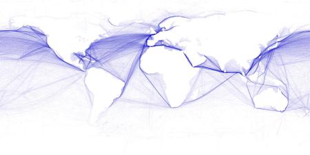
Figure 6 Density of Commercial Shipping Activity, 2009
Adapted by Hengl, T.
(2010).
Shipping Routes.
Retrieved
(04.30.12)
from,
oute
Based on Harper, B.S.,
Walbridge, S., Selkoe, K. A., Kappel, C.V., Michelo, F., D’Agrosa, C., … , Watson, R. (2008), A global map of
human impact on marine ecosystems.
Science
.
(319)5865, 948-952. doi: 10.1126/science.1149345
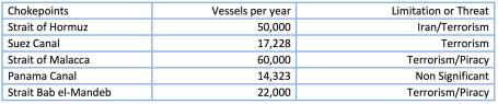
The closure of the Suez Canal in 1956–57 forced ships to circumnavigate the southern tip of Africa
around the Cape of Good Hope. Since the 1950s, traffic on the world’s oceans has increased
substantially, and any interruption along a vital shipping route would have a significant effect on
international trade and the global economy. The threat of piracy continues to affect shipping traffic
as well. Until the 1990s, piracy was prevalent throughout the Strait of Malacca, and safety concerns
remain along the eastern seaboard of Africa. A sea route through the Arctic would thus represent an
alternative to the sea-lanes around the Horn of Africa and the choke points of Southeast Asia (Jian,
2011).
Table 3
Choke points in Global Shipping, 2009
Adapted from PricewaterhouseCoopers (2011b).
Transportation & logistics 2030
. Retrieved (04.30.12) from,
030